High altitude (>4000m😎) adventures in 🇲🇦 Morocco
|
🇲🇦 Morocco hosts the highest peaks in North Africa in the high Atlas Mountain Range. Standing above all, you can find Mt. Toubkal (4167m).
The hike to Mt. Toubkal is by far the most notorious trek in Morocco and North Africa. Every blog or newsletter has already covered all the must-knows.
That's why we'll examine some 🤓 curious facts and 🏔️ all the alternative routes to summit Mt. Toubkal.
|
Mount Toubkal ascent in Winter.
|
Mt. Toubkal is the highest peak in North Africa, but... |
Yes, that is true. But would you be surprised if I told you that Mt. Toubkal is only the 29th highest peak in the whole Africa? 🤯
The ranking of the highest peaks in Africa goes:
1. 🇹🇿 Kilimanjaro - Kibo peak (5895m)
2. 🇰🇪 Mt. Kenya - Batian peak (5199m)
3. 🇨🇩🇺🇬 Mt. Stanley - Margherita peak (5109m)
...
29. 🇲🇦 Mt. Toubkal (4167m)
Last curious fact, did you know there are 16 peaks above 4000m in 🇪🇹Ethiopia? I didn't. 😅
|
The shrine of Sidi Chamharouch |
Mid-way on your hike from Imlil to the Toubkal refuges, you'll notice a big white-painted boulder (❌ this one is not for climbing!!) 👇🏼 with a little building built around it: the shrine of Sidi Chamharouch, king of the Jinns. Make sure to stop here and take a look!
This is a very peculiar place which is considered sacred by the Berber culture. The legend says that Sidi Chamharouch has inhabited the mountain's slopes since time immemorial, deciding to transform them into his tomb. Since then, floods of pilgrims come here every year to seek healing from the king of Jinns.
|
🏔️ Mt. Toubkal: all routes 🥾🎿 |
1️⃣ 🥾 Summit via the South Col
- Distance: 7km
- Hiking time: 2-3h (only ascent)
- Elevation gain: 1000m
- Fatmap GPX 👉🏼 click here
- This is the main and most popular route to the summit. This is the "easiest" route. But don't worry, it will challenge you. The route is accessible both in summer and winter depending on conditions.
|
2️⃣ 🥾 Summit via the North Col
This is a far less popular popular route to the summit. Sometimes hikers make a loop and descent from this route after ascending from the South Col.
Summiting via this route means no crowds and a far more less-beaten-path to the summit. The route is accessible both in summer and winter depending on conditions.
|
3️⃣ 🎿 Summit via the South Col and other ski-touring itineraries.
For all the ski mountaineers reading, don't worry, we have one big adventure for you. You can summit Mt. Toubkal (4167m) with skis and descent nearly 2400m directly to Imlil. Quite the adventure, right? There is also a 40° steep passage to ski down 🥶. We found this adventure on Fatmap GPX 👉🏼 click here to check it out.
Alternatively, you can ski up and down the normal route through the South Col (Fatmap GPX 👉🏼 click here) and descend to the refuges.
Consider that, starting from the Toubkal refuges, there are also other ski-touring possibilities on the nearby 4000 peaks. Check them on Fatmap 👉🏼 click here.
|
Click the map to open the image.
|
Click the map to open the image.
|
|
|
✨ If you'd love to start planning your next adventure in Morocco or elsewhere in the world, we are here for you, just fill the form below and let us know 🥰👇
|
Are you looking for your next outdoor sport trip or expedition? |
|
|
Mapo Tapo behind the scenes on IG stories 💌🚀
|
👀 Hey, have you noticed our Instagram Stories lately?
We have been posting some "behind the scenes" about our adventures inside and outside the Mapo Tapo office.
We want to show you all the cool things about the Mapo Tapo trips, but also all the work we put it to make it happen...and, why not (?!), some silly and funny things about ourselves to show the faces behind Mapo Tapo.
After all, are we not one big community of outdoor sports lovers? 😍
|
|
|
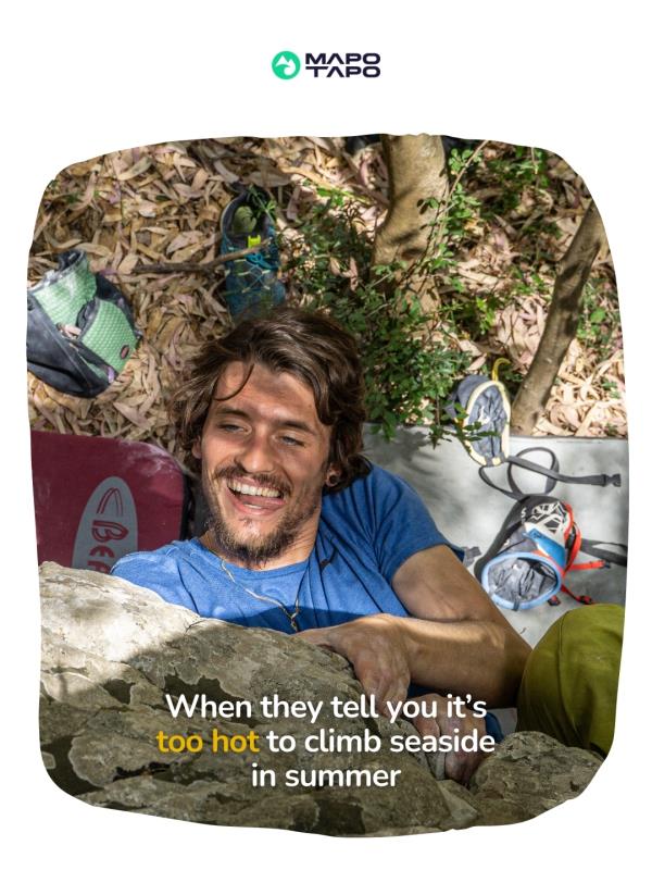
📸 Pics from the community |
Discover Mapo Tapo through our travelers' eyes! In each newsletter, we'll be featuring a selection of our favorite snapshots taken during our trips worldwide.👇 Here's what you missed during our recent trip to 🧗♀️🇮🇹 Sicily.
|
|
|
|
@ Mapo Tapo S.r.l. at Viale Piceno 6, 20129, Milan, Lombardy, Italy.
Don't want to receive emails from us? Manage your email preferences here.
|
|
|
|